Wednesday, December 22, 2010

Pelorous Bridge

On Wednesday night, we camped at the DOC campsite at Pelorous Bridge in the mountains between Picton and Nelson. This was a "serviced" campsite and, as such, had the greatest range of facilities of any of the DOC campsites we had stayed at so far. Warm showers? Gas hob for cooking? We were impressed.

It also had great views of the river which was still swollen after the recent rain. Here is the view from our van:


We arrived early enough to go out and explore the area a bit too. We were advised to check out the swing bridge over the nearby river Rai:


I was able to tempt Hannah to cross this bridge, from which can be seen the confluence of the Rai and the Pelorous in the distance:


We also climbed on the rocks by the Pelorous River. As you can see, these rocks are particularly geological:


Our hosts at the campsite also recommended walking to a nearby waterfall where glow worms can be found. We duly did this and found our path blocked by a stream gushing with the water of the recent rains. Hannah was unable to cross but I made it to the other side and found where I thought the glow worms ought to be. I'm not sure if the worms were actually glowing at the time, mind, since the sun had yet to go down completely.


The waterfall itself was pretty beautiful:


DOC campsites never cease to amaze me. The are the cheapest campsites available and are also almost always sited in the most wonderful locations.

Friday, December 17, 2010

Fox Glacier

We spent Friday night in a campsite near Haast, the rain hammering down on our puny little campervan from dusk til dawn. I was woken by Hannah's distressed cries; she had just discovered that her trousers had fallen out of the van when she went to the toilet during the night and were now lying in a muddy puddle.

We sheltered from the rain in the kitchen, finding time to chat to a Kiwi couple who, it turned out, had worked at the same place as Hannah in Lymington during the 90s. Finally, we plucked up the courage to high tail it out of there. We headed for the most southerly part of the west coast that can be reached by road (apart from Milford Sound): Jackson Bay.


Unfortunately, Jackson Bay was a bit rubbish in the rain and we only spent a few minutes there before the sandflies chased us back to the van. It's a shame that the weather was so terrible because I bet that there would have been some lovely views of the mountains on a sunny day.


Next, we headed up the coast to the Fox Glacier which might or might not have been named after a brand of sweets. We decided to visit the glacier ourselves, rather than paying a fortune to take part in a guided tour. The torrential rain again cussed our plans:


Still, we could see some of the glacier beyond the safety barriers and it was an awesome sight.


The cliffs at the side of the valley were impressive too. Notice how the strata in the rock are nearly vertical, which is indicative of some kind of geological process having folded the rock.


One result of the recent rainfall was that, downstream from the glacier, the Fox River was a raging torrent of water and ice:


On our way back down the valley, we sighted a "historic bridge". This was built many years ago and was used by visitors to access the glacier back when the glacier extended a little further down the valley.


Hannah didn't fancy crossing the bridge for some reason so I crossed it alone. It was actually pretty scary with the river below in full flow:


Sadly, we didn't have time to stick around any longer and we headed off to the DOC campsite where Hannah attempted to dry her trousers out on our Bear Grylls style washing line. It was a shame to have to leave so soon. I would have loved to get a closer look at the Fox Glacier or its slightly more famous neighbour the Franz Joseph Glacier.

Thursday, December 16, 2010

Mount Cook

On Thursday, we made a quick dash up from Wanaka to visit Mount Cook, New Zealand's tallest mountain. Eventually arriving at Mount Cook Village, we were as close to the mountain as we could get by car. Mount Cook could be seen in the far distance.


A glacier (I forget which one) was easily visible above where we stopped.


We decided to pop in to the Edmund Hillary Centre, dedicated to the legendary Sir Edmund, a local Kiwi hero who led the first expedition to conquer Everest.


Interesting though the Everest stuff was, I was intrigued to learn that Hillary had also been a legendary explorer of the Antarctic. In 1958 he led the first team to reach the South Pole since Scott in 1912. It was on the snowfields around Mount Cook that the team did much of the training for their expedition.

The centre had some tractors that saw use in the Antarctic.


Upon seeing them, I remembered my dad's Antarctic stories and wondered what would happen if one of them fell down a crevasse...


As evening was drawing in, we made camp in the nearby DOC campsite, resolving to make the walk up the Hooker Valley to the end of the Hooker Glacier the next morning. The sunset was beautiful and that ought to have been an omen of good weather to come in the morning.


Of course not. During the night, the heavens opened; it turned out that this was the end of a long drought and that the rains were welcomed by the area's farmers. It was still raining heavily in the morning, cussing our plans of making the walk up the Hooker Valley. We made plans instead to head straight to the Fox Glacier, which also originates from Mount Cook and heads west, down the other side of the mountains from where we were. Despite its proximity, we had a day's drive ahead of us to get there since there was no direct route across the enormous mountains of the Southern Alps. Our route therefore took us, back to Wanaka and across the Haast Pass. This we did in a hurry as the rain beat down.

We camped at a campsite near Haast that evening, hoping that the weather would clear up by morning.

Wednesday, December 15, 2010

The Road To Wanaka

On Wednesday, it was finally time to leave the Queenstown area. After spending a few hours running round town in a vain attempt at finding my lost phone, we hit the road. We decided to take the cross country route out of town, beginning with the bridge over the Shotover River.


Our route crossed the Crown Range. As we climbed the zig zag into the mountains, we could see views back in the direction of Queenstown which was by now hidden behind an inconveniently placed mountain.


The Remarkables range of mountains could also be seen behind us.


We didn't realise it at the time but we were heading into one of New Zealand's driest areas. It didn't take long for the hillsides to lose their green shade.


The views along the road were both beautiful and strikingly different to what we had seen so far.


I can only assume that the geological makeup was just as different from that we were leaving behind. I don't know what sort of rocks made up this terrain but I saw, at various times, what looked like limestone, sandstone, chalk and, finally, slate:


As we crossed the watershed and began descending towards Wanaka, the transformation in the landscape was nearly complete:


Here is a picture of Hannah showing her appreciation for all my geological musings:


When we arrived in Wanaka, the guy at the campsite complained about Wanaka's lack of rainfall and, after showing us to the best site in the place, put the sprinklers onto his parched yellow grass. Little did he know that, a couple of days later, the months long drought would come to an abrupt end.

Tuesday, December 14, 2010

Shotover Swing

We spent a little under a week in the Queenstown area. We had previously been advised by pretty much every Kiwi that we met that Queenstown is "too commercial" and has been "ruined" by the "tourists". Being tourists ourselves, we couldn't help but feel slightly guilty as we pulled into town. People were half right, too. Queenstown is very touristy and rather commercial. We were pleasantly surprised to discover that it wasn't rubbish, however.

Our campsite was the slightly oddly named QBox site. Despite the odd name, it was actually rather awesome and I feel obliged to plug it to the max on this blog. It was owned by a couple who had recently bought the land and used old shipping containers to build the buildings that housed amenities such as toilets, laundry and kitchen.

What about the town itself? Everything that we had read about Queenstown had billed the attractions as being exciting and adrenaline fuelled. Having already sampled the rather tame excitement of kayaking on Lake Wakatipu, we had to push the envelope a little. I decided that it would be a good idea to go on the Shotover Swing. This is billed as "The World's Highest Cliff Jump" and involves jumping off a cliff, freefalling for 60m and swinging across the bottom of Shotover Canyon.

Our host, Nick, picked us up from the office in Queenstown and whisked us up to the canyon in his 4WD minibus. The drive itself became pretty scary towards the end but we made it in one piece.


Before heading down to the jump, I decided to use the only urinals on site. Here is the one that I used.


On the way down, a sign pointed out the distances to all of the places that we might never see again in the event of a horrible bungee accident. I was particularly impressed to see Llanfairpwllgwyngyllgogerychwyrndrobollantisiliogogogoch on the sign, although I'm not sure if the direction is 100% accurate.


We then headed down to the jump platform, which was at least as scary as it looks here. Lord of the Rings fans might recognise the canyon below; the Ford of Bruinen is set a few km further up the canyon (that's the scene where Liv Tyler is carrying Frodo on her horse and summons up the river waters to drown the persuing Ring Wraiths).


Nick cruelly decided that I was to be the first to jump so I was quickly harnessed up and standing on the jump platform before I knew it. This was intensely frightening and I wouldn't go anywhere near the edge in case they pushed me off it. After taunting me for my lack of jumping off, the jump master eventually agreed/ that my jump would be a cutaway. I was attached to another wire and hauled a few metres off the platform and suspended above the canyon. I was then invited to pull a wire above my head in order to be released. This I did and...

...

To be honest, I'm not really sure what happened next. I have a vague memory of a rush of sheer terror and I remember swearing uncontrollably. The next thing I knew, I was swinging around the bottom of the canyon, completely disoriented, with pins and needles in my arms. After a few seconds, I was winched back to the top and the ordeal was over.


Unless I wanted another go, of course. Which I did. I had to wait for everyone else to have a go (sadly not including Hannah, who had decided not to participate) before heading back to the platform for my second go. This didn't go as smoothly as the first one; the jump master told me that I wasn't allowed another cutaway and this time would have to jump off. This sent me back into panic mode and I spent the next 15 minutes being berrated and insulted for my refusal to go anywhere near the edge. I tried to explain that I have a slight fear of hights and, besides, it's rather unnatural to hurl yourself from the top of a cliff but to no avail.

Nick eventually came up with a compromise: He would hold onto the rope attached to my harness as I leaned from the edge of the platform. Then, when I was ready, he'd release me. Naturally, him being a totally swine and all, he dropped me as soon as I started to lean off the platform, leaving me swearing profusely and uncontrollably again on my way down. Again, I don't really have much of a memory of the actual drop, just a feeling of sort of "coming to my senses" afterwards, noticing that I was swinging around the bottom of the canyon, wondering what was going on. And that was that. I didn't fancy doing it again so I paid an extra $70 for a DVD of my (first) jump and we headed home. I swear I must have been in shock because the rest of the day was a bit of a blur. And I lost my phone.

Was it worth it? I don't know. I certainly wouldn't describe the experience as being enjoyable. Clearly I am not enough of an adrenaline junkie for this sort of thing because there was a little too much adrenaline. I would put it into the category of "things you do because you don't want to see yourself as the person who chickened out of doing that thing". At least I was successful in that. Sort of.

Saturday, December 11, 2010

Kinloch

On Friday, we found ourselves in the Queenstown region. Having been told by a few people that Queenstown is overly commercial, touristy and a bit rubbish, we decided to head for the tiny hamlet of Kinloch, at the "kin" of "loch" Lake Wakatipu. Almost as soon as we arrived at the Kinloch DOC campsite and paid our fees, the heavens opened. We spent most of the afternoon sheltering from the rai in the cafe at Kinloch Lodge drinking coffee and trying to work out what we were going to do. We went for a quick drive around the area but didn't dare go out for long in the pouring rain.

After rehydrating a freeze dried meal for dinner and fighting a losing battle trying to keep our side awning upright, we retired to bed. The next morning was much better. The rain had stopped and we were finally able to see what a beautiful spot we had camped in:


A guy from Kinloch lodge took us out kayaking on the lake for an hour which was great fun, albeit a bit tiring/scary when the wind really picked up on the way back.

We left Kinloch and headed towards Queenstown, passing some beautiful scenery on the way:


When we reached Queenstown, we were pleasantly surprised to discover that, while it was commercial and touristy, it wasn't completely rubbish.

Friday, December 10, 2010

Lake Gunn

Last night, we camped at the DOC campsite by Lake Gunn. This is the view that greeted us in the morning:


To think, we only started staying at DOC campsites because they are cheap (or free in the case of the "basic" DOC campsites). There are about 10 DOC such campsites between Milford Sound and Te Anau and we camped at the first DOC campsite that we came to. This one just happened to be set in the loveliest location imaginable. We were lucky to get a space, too; in the few hours after we set up camp, a steady stream of campervans arrived, looking for a place to camp. The last few left, disappointed, and presumably ended up at the much less picturesque campsites further down the road.

Aside from a hoard of fellow campers, we also shared the campsite with more ferocious sandflies. And a family of ducks.


Quack quack!

Thursday, December 09, 2010

Mirror Lakes

On Thursday morning, we set off from Lake Gunn, our eventual destination being the Queenstown area. As the crow flies, this wasn't very far but, alas, a mountain range stood in our way and no one had been kind enough to build a road for us to drive across it. Therefore, we went the long way, via Te Anau.

On the way, we reached Mirror Lakes. These lakes were apparently famous for their still water, creating a clear reflection of the mountains behind. The mountains were certainly impressive too, reminding me of the Sierra Nevada mountains in California (I heard an American chap saying the same thing so it must have been true).


The lake itself was indeed pretty calm and reflective. I'm not sure it was impressive enough to justify the enormous hoards of tourists swarming around it. Tourists, eh?

Wednesday, December 08, 2010

Milford Road

On our way back from our visit to Milford Sound, we had a little more time so we stopped frequently and took a lot of pictures.

Our first stop allowed us to snap the mightly Cleddau River, named after the Cleddau rivers that feed Milford Haven in South Wales.


A little further up the Cleddau valley, we came upon "The Chasm", a little waterfall where the Cleddau River plunges down a drop of a few metres and which was considered important enough for someone to build a boardwalk to get there. We felt a little disappointed by it but I think that there is often a lot more water flowing.


When we reached the head of the valley, we really knew it; the valley ended rather abruptly.


This must have been a formidable barrier to early explorers. Luckily, someone had built The Homer Tunnel between the head of the Cleddau Valley and the head of the valleys of the Eglington and Hollyford rivers.


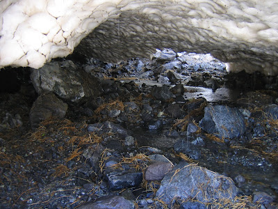
On the other end of the Homer Tunnel, we found a big load of ice that still hadn't melted. I was hoping that we'd found a real live glacier but I don't think it was flowing anywhere.


The ice was melting rapidly and the water was flowing underneath the ice:


I noticed that Hannah was standing on the ice immediately above this icy cave and, remembering Dad's stories of cravasses in the Antarctic, I quickly called her off the ice. It was rather worrying to watch a steady procession of people climbing up onto the ice but hey, I thought: If it was that dangerous then someone would have put up a warning sign. Oh, wait, what's this tiny sign?


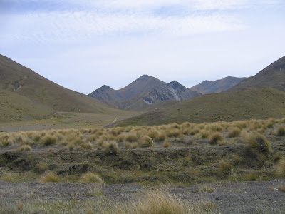
On the way back, we saw some mountains in the distance.


Finally, we made our way to Lake Gunn DOC Campsite and made camp for the night. All in all, a fun day.